Read the Final Report!
The Route 146 Corridor Management Plan Final Report and appendices have been completed and posted to the Documents webpage.
The Connecticut Department of Transportation (CTDOT) partnered with the consulting firm VHB to develop a Corridor Management Plan (CMP) for CT Route 146 in Branford and Guilford. The CMP was created to review the Route 146 corridor and how to protect its many historical, cultural, and environmental resources. The CMP balances caring for these important resources with providing a safe roadway for all travelers, respecting the desires of the community, residents, and local businesses. It also looks at ways to make the corridor more resilient—more prepared for climate risks like flooding.
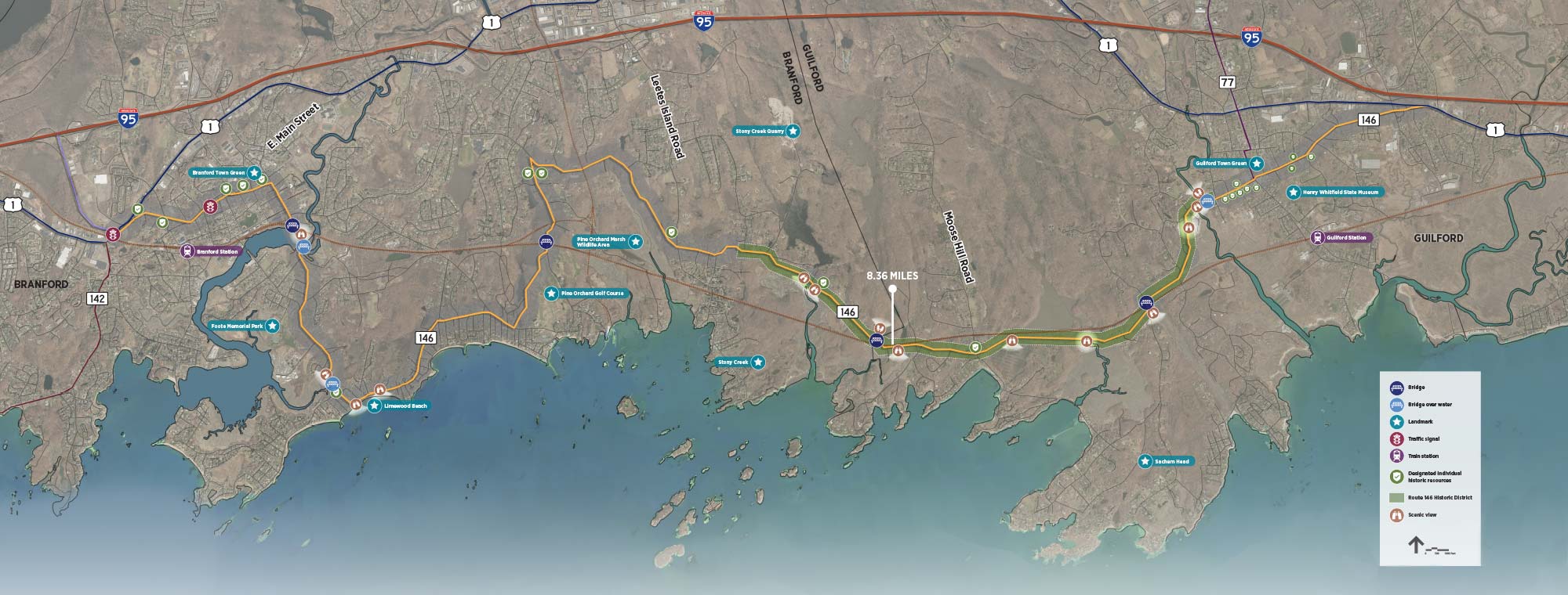
Connecticut Route 146 stretches 13 miles from Route 1 (North Main Street) in Branford to the intersection to Route 1 (Boston Post Road) in Guilford. It is a scenic road connecting Branford and Guilford with the coast of the Long Island Sound. Visitors can see historic homes, wildlife habitats, and scenic views by walking, biking, or driving. The low-speed, winding roads are a pleasant and calming travel experience compared to Route 1 or Interstate 95.
Many places along the road are listed as Designated Historic Resources on State and National Registers. The Route 146 Historic District runs between Flat Rock Road in Branford and Water Street in Guilford, and the corridor runs through six more National and Local Historic Districts: the Canoe Brook National Historic District, the Branford Center Historic District, the Stony Creek – Thimble Islands Historic District, the Guilford Town Center National and Local Historic Districts, and the Whitfield Local Historic District. In 1990, Route 146 was made a State Scenic Road from Eades St. in Branford to the end of the road in Guilford at Route 1, the second route in the state to receive this designation.
Click the map above or this link to view the Route 146 Corridor in more detail. (PDF)
A Corridor Study for Route 146 was started by the South Central Regional Council of Governments (SCRCOG) in 2019, and an existing conditions report was created in early 2021. Most of the road is a State Scenic Roadway that goes through many different areas, from downtown commercial areas in Branford and Guilford near US Route 1 to more rural and less-populated residential areas along the marshy coastline.
During the Corridor Study, people asked for a more comprehensive review of the corridor because of its many historical, cultural and environmental resources. Because of these comments, SCRCOG and state officials agreed that a Corridor Management Plan was a better way to look at how to protect and enhance Route 146’s intrinsic qualities and character. An important part of creating the CMP was getting the local communities more involved.
What is the difference between a Corridor Study and a CMP? A corridor study looks at a road and the land it travels through and analyzes how safe the road is, how easy it is to access, and how well travelers use it. If there are problems, potential fixes are proposed which may turn into transportation projects to make travel safer and easier for everyone who uses the road. A CMP is less technical. It takes a bigger picture look at the land and community the road travels through and gives local residents more chances to weigh in. A CMP also focuses more on protecting the intrinsic qualities and things—historic and environmental—that make the corridor special. The CMP for Route 146 helps guide possible future changes to the corridor to make it safer for everyone who travels it, to maintain its infrastructure (roads, lights, etc.), and to better protect it from sea level rise and flooding.
A previous Corridor Management Plan for Route 146 was developed in 1996. The vision for this CMP was to preserve and protect the unique qualities of Route 146. View the Routes 77 and 146 Corridor Management Plan from 1996.
An example of another Corridor Management Plan in the state is the Route 169 Corridor Management Plan for the towns of Woodstock, Pomfrey, Brooklyn, Canterbury, and Lisbon in eastern Connecticut. You can find more information about the plan on the website for the Northeastern Connecticut Council of Governments. Both plans can also be found in the Documents section of this website.
Find ways to make future changes on Route 146 that protect and enhance the unique qualities of the road and the community, and also improve traffic safety, resilience (protection against weather hazards) and road maintenance.
Improve communication at local, regional and state levels through public outreach and public meetings to gather feedback on the needs and desires of the public and the communities the corridor passes through.
Identify key environmental, cultural and historic resources along the corridor, including vistas and viewsheds. Expand on these resources from the 2021 Route 146 Existing Conditions Report and any other key documents.
Develop strategies for giving bicyclists and pedestrians better access to the road.
Come up with ways to improve areas of the corridor that frequently flood and areas that could be affected by rising sea levels to provide a resilient roadway for future generations.
Identify and address safety concerns through the corridor to improve public safety for all travelers.
Make any repairs to the corridor’s infrastructure (road, lights, etc.) to provide a safe and climate-resilient corridor.
Form a working group to act as a steering committee for the project, which will include staff from CTDOT, representatives from the Branford and Guilford, and others. The members of this working group will attend a series of workshops and will work closely together to complete the Management Plan Framework.
Balance needs and desires of residents and local businesses with legal requirements and engineering design standards.